Carlsbad Watershed Issues
- San Diego County's coastal riparian and shoreline habitats are under attack by invasive plants and animals.
- Development causes erosion of our hillsides and canyons and increases sedimentation of our creeks and lagoons, resulting in destruction of these fragile ecosystems.
- Water quality deteriorates due to urban runoff, contaminants, bacteria and loss of the filtering properties, stream buffering, and native vegetation.
NEW: Evaluation of Wetlands Mitigation Sites Reveals Regulatory Shortcomings
Preserve Calavera succeeds in raising funds to purchase 134 acre Sherman property! More .
You can help.
 |
 |
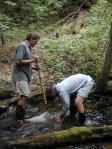 |
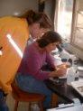
| Watershed Stewards Volunteer citizen training to monitor water quality of local streams. More. |
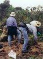
Invasives Removal Project Non-native plants displace native plants and destroy wildlife habitats. More. |
Get Involved Volunteer for stream clean up or invasive removal. Provide public testimony. Make presentations. More. |
Roadmap for ActionAgua Hedionda Watershed Management Plan Watershed Management Plan | FAQ's About the WMP | Executive Summary | Technical Reports and Appendices | | Meeting Agendas and Presentation | Small Changes Brochure |
||
Watersheds: we all live downstream.
The term "watershed" describes an area of land in which waters drain down slope, along a drainage to a common lowest point or basin. The water drains via a network of surface and underground drainage pathways, and generally these pathways merge into a stream or river system that becomes progressively larger as the water moves downstream. Ground and surface waters may also merge or separate at various points along the pathway to the recipient water body that collects drainage from the watershed.
Because the water naturally moves downstream in a watershed, any activity affecting the water quality, quantity, infiltration, or rate of drainage at one location in the watershed can change the physical, chemical, and biological characteristics at downstream locations. The physical connection between tributaries and larger streams and rivers, between surface and ground water, and between wetlands and all of the water sources, drive the need to plan and manage at the watershed level.
Carlsbad Hydrologic Unit
Within California, the State Water Resources Control Board (SWRCB), defines a "hydrologic unit" as major watersheds that drain to a terminal receiver water body- in our case, the Pacific Ocean. These hydrological units are subdivided into hydrologic areas or watersheds. The Carlsbad Hydrologic Unit contains seven coastal watersheds and ten sub areas that drain into either one of four major coastal lagoons or directly to to the Pacific Ocean .

The Carlsbad Hydrologic Unit (CHU ) covers 210 square miles, portions of Oceanside, Vista, San Marcos, Escondido, Encinitas, Solana Beach, Carlsbad, and the County of San Diego and includes seven adjacent coastal watersheds that drain to the Pacific Ocean including the Loma Alta Creek, Buena Vista Creek, Agua Hedionda Creek, Canyon de las Encinas Creek , San Marcos Creek, Cottonwood Creek, and Escondido Creek. The CHU contains four major coastal lagoons: Buena Vista, Agua Hedionda, Batiquitos and San Elijo, as well as, the Loma Alta Slough . More
Invasive Brochures |
||
 |
 |
 |